
Each weekly exercise is designed to teach integration of data from various formats, data analysis, and how to display results for decision making processes.
 Turning Data into Information Using ArcGIS 10
Module 1: Basics of Data and Information
Problem: Geographic data links information about a location and its features (i.e. attributes), possibly with a time component … more.

Problem: The coordinators of a local art showcase have tabular address data, but would like to visualize spatially where their attendees come from, so they can better direct future marketing … more.

Problem: Develop a file geodatabase for the NC State University campus containing specified featured classes using data from a CAD file that is not georeferenced. … more.
 Database Cardinality Issues in ArcGIS
Problem: NC Senators and Representatives have requested the exact number of NC jobs created in their district based on the results of a recent industrial extensions jobs survey. … more.

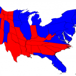
Problem: Create a thematic map using an attribute from the US census data for any geographic area. … more.

Problem: Determine if road ratings are associated with the number of accidents using linear referencing. … more.
 Basics of Raster Data & Using Raster Data for Site Selection
Problem: Raster data and vector data complement each other, however sometimes raster data is required for certain spatial analyses, … more.
 Suitability Analysis & Weighted Overlay
Problem: Wildlife biologists working in Great Smoky Mountains National Park are seeking to define areas of bear habitat within the park where human interactions are unlikely to occur … more.

Problem: Use image classification to determine locations of land cover classes within Black Water National Wildlife Refuge, Maryland … more.

Problem: Use various spatial statistical methods to determine if false fire alarms for Battalion 2 of the Fort Worth Fire Department exhibit clustering and assess the level of clustering … more.
 Customizing the ArcMap Interface
Problem: Create two custom toolbars, including a custom drop-down menu and a button for an add-in, add a tool to the layer context menu, and populate an attribute table using the add-in functionality … more.